Lucknow. Friday, 26 June 2026
The India Meteorological Department (IMD) has issued a fresh weather advisory for Uttar Pradesh. As the southwest monsoon aggressively advances northward, residents across central and eastern parts of the state are urged to stay highly vigilant. While the incoming rain promises long-awaited relief from a punishing summer, the transition brings severe risks of thunderstorms, high-velocity gusty winds, and dangerous lightning strikes.
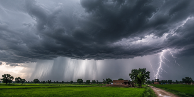
Monsoonal Advance Confronts Severe Heatwave in East UP
The meteorological transition in Uttar Pradesh is currently presenting a dual-hazard scenario. Extreme heatwave conditions are expected to hold their grip tightly over isolated pockets of East Uttar Pradesh through June 26–27. However, this extreme heat is acting as thermal fuel. As the moist, cool winds of the southwest monsoon collide with the hot air mass, atmospheric instability is peaking, setting the stage for violent convective storms.
Meteorologists indicate that conditions remain highly favorable for the monsoon to push deeper into the state over the next few days. This will trigger widespread precipitation, an increase in agricultural moisture, and a steady drop in daytime temperatures.
Rain, Wind, and Thunderstorm Forecast Breakdown
According to the IMD’s official warning system, weather patterns over the coming days will shift dramatically:
-
Lightning & Thunderstorms: Multiple districts across central and eastern UP are high-risk zones for severe cloud-to-ground lightning alongside brief but intense spells of rain.
-
Isolated Heavy Rainfall: As monsoonal surges strengthen, localized pockets will experience torrential downpours capable of causing urban flooding and waterlogging.
-
Gusty Winds: Sudden, strong winds accompanying the squall lines threaten to uproot weak trees, damage fragile structures, and disrupt electricity grids.
IMD Essential Safety Action Plan
To minimize risk to life and property, the IMD has laid out clear guidelines for residents, commuters, and the agricultural sector:
-
For Residents: Stay securely indoors during active thunderstorms. Secure loose outdoor furniture, tins, or objects that could become airborne missiles in high winds.
-
Seeking Shelter: Never take refuge under isolated trees, tin roofs, or near high-tension electric poles during a lightning storm.
-
For Motorists: Drive with extreme caution. Heavy downpours will drastically reduce visibility and make roads slick. Avoid underpasses prone to sudden water accumulation.
-
For Farmers: Postpone harvesting operations and chemical/pesticide spraying until the immediate thunderstorm threat clears. Keep a close watch on real-time localized radar updates.
Frequently Asked Questions (FAQ)
When will the heatwave completely end in Uttar Pradesh?
Severe heatwave conditions in eastern UP are projected to gradually ease after June 26–27 as monsoonal rainfall becomes more widespread and effectively cools the region.
Which areas of UP are under a heavy rain alert?
The IMD has primarily flagged eastern and central Uttar Pradesh for immediate thunderstorms and lightning, with expanding rainfall expected across the rest of the state as the monsoon moves further north.
What should farmers do during this monsoon transition?
Farmers should closely monitor local weather bulletins, suspend harvesting or chemical spraying temporarily, and ensure proper drainage channels are clear to handle sudden heavy downpours.
Disclaimer: This article is prepared for informational purposes based on weather advisories issued by the India Meteorological Department (IMD). Weather conditions can evolve rapidly. Readers are advised to cross-reference real-time alerts with local administration updates.
For more regional news and localized updates, visit Matribhumi Samachar.