 Matribhumi Samachar English


Toronto, Ontario–(Newsfile Corp. – August 25, 2026) – Arizona Eagle Mining Corp. (TSXV: AZEM) (OTCQB: AZEMF) (the “Company” or “Arizona Eagle”) is pleased to announce results from the final five holes of its Phase 1 drill program (the “Phase 1 Drill Program”) on the highly prospective Eagle Project, located in the historic McCabe gold-silver mining district in Arizona. The Phase 1 Drill Program’s objective was to target multiple northeasterly-striking, steeply-dipping sulphide-bearing quartz veins that may extend beyond the area covered by the historical resource estimate of approximately 880,000 ounces of gold at 11.7 g/t at McCabe (the “Historical Estimate”).
These initial drill holes targeted the potential to the northeast, outside the area covered by the Historical Estimate, and intersected high-grade gold mineralization that remains open along strike, extending the mineralized strike by about 50 metres beyond the approximate 750 metre strike length covered by the Historical Estimate.
Drill holes Eagle-26-05 and Eagle-26-06, located approximately 200 metres and 250 metres northeast, respectively, of the McCabe Mine, both intersected high-grade zinc-silver VMS type mineralization. These intervals are on strike with three past-producing silver mines, recently acquired by Arizona Eagle, which are located approximately one kilometre northeast of the McCabe Mine. The zinc-silver VMS intervals appear to have many similarities to the past-producing Iron King Mine1, located approximately four kilometres on strike to the northeast of the McCabe Mine. Historic records at the Iron King Mine reported production from 1903 to 1969 of 5.7 million tons at a grade of 2.6 g/t gold, 98 g/t silver, 4.9% zinc, 1.8% lead, and 0.1% copper. The Iron King Mine was mined to depths below 1,000m, whereas the vertical depths of the VMS intervals reported in this release are at only approximately 150 metres.
Kevin Reid, Chief Executive Officer of Arizona Eagle, commented:
“The recently concluded Phase 1 drill program has validated our belief that high-grade gold and silver mineralization remains open beyond the area covered by the Historical Estimate. With the system open along strike and our drilling now stepping out toward our recently acquired Eagle Silver Project, we are excited about the district-scale exploration potential we are unlocking. Our second hole successfully tested the northeast extension beyond an interpreted fault offset where historic mining and underground exploration stopped. This shows the potential to define additional mineralization northeast of the area covered by the Historical Estimate. Holes five and six have intersected zinc-silver VMS type mineralization, which appears to be similar to that of the past-producing Iron King Mine, located four kilometers to the north. Initial drilling and sampling have identified a number of exploration targets on the Eagle Project in various types of mineralization. We are now compiling these results and have also commissioned a detailed SkyTem airborne geophysical survey to help delineate mineralization types and refine targets for a Phase 2 drill program.”
| HoleID | From (m) |
To (m) |
Length* (m) |
Au (g/t) |
Ag (g/t) |
Cu (ppm) |
Zn (%) |
Pb (%) |
| Eagle-26-01 | 355.7 | 356.9 | 1.2 | 2.73 | 3.28 | – | – | – |
| 410.9 | 412.4 | 1.5 | 2.23 | 6.03 | – | – | – | |
| 442.6 | 443.5 | 0.9 | 5.09 | 16.35 | – | – | – | |
| 446.8 | 447.6 | 0.8 | 1.86 | 1.50 | – | – | – | |
| Eagle-26-02 | 402.6 | 406.8 | 4.2 | 5.73 | 5.90 | – | – | – |
| including | 404.2 | 406.8 | 2.6 | 8.05 | 7.73 | – | – | – |
| and including | 406.0 | 406.8 | 0.8 | 11.35 | 11.15 | – | – | – |
| Eagle-26-02a | 375.5 | 377.2 | 1.7 | 1.16 | 7.38 | – | – | – |
| 379.6 | 382.4 | 2.8 | 0.54 | 5.99 | – | – | – | |
| Eagle-26-03 | 397.1 | 398.7 | 1.6 | 0.95 | 4.90 | 237 | 0.7 | 0.05 |
| Eagle-26-04 | 384.4 | 388.3 | 3.9 | 0.52 | 4.34 | 162 | 0.6 | 0.08 |
| Eagle-26-05 | 206.7 | 218.5 | 11.8 | 0.17 | 9.17 | 130 | 1.7 | 0.25 |
| including | 206.7 | 208.2 | 1.5 | 0.38 | 14.45 | 118 | 2.4 | 0.48 |
| including | 211.5 | 213.7 | 2.2 | 0.66 | 36.30 | 379 | 6.9 | 0.97 |
| 240.8 | 242.3 | 1.5 | 0.26 | 7.09 | 73 | 1.3 | 0.27 | |
| Eagle-26-06 | 223.1 | 224.0 | 0.9 | 0.79 | 8.15 | 236 | 17.1 | 0.01 |
| including | 223.4 | 224.0 | 0.6 | 1.17 | 12.05 | 345 | 25.5 | 0.01 |
| 274.9 | 275.5 | 0.6 | 0.46 | 9.22 | 361 | 3.0 | 0.03 | |
| 327.5 | 328.7 | 1.2 | 0.18 | 5.76 | 174 | 2.9 | 0.06 |
Table 1. Phase 1 Drilling assay intercepts (*more drilling is required to confirm true widths)
Drill Hole Descriptions:
EAGLE-26-03, EAGLE-26-04, EAGLE-26-05 and EAGLE-26-06 were designed to test the northeastern extension of the McCabe-Sooner mineralized system beyond the limits of the historical underground workings. Holes EAGLE-26-03 and EAGLE-26-04 intersected a sulphide-rich shear zone from approximately 390 to 400 m and 380 to 388 m downhole (vertical depths of approximately 150 metres), respectively, approximately along strike from the historically mined mineralization. The shear zone interval is characterized by blebby and banded arsenopyrite, pyrite, sphalerite, galena and tetrahedrite, accompanied by subordinate ductilely deformed quartz veining.
Stepping out further northeast, holes EAGLE-26-05 and EAGLE-26-06 intersected mineralization at shallower downhole depths (from 205-220 m and from 222-225 m downhole, respectively) and relatively off-strike from mineralization encountered in EAGLE-26-03 and EAGLE-26-04, suggesting post-mineral fault displacement, a bend or jog in the principal structure, or a separate mineralized structure. Additionally, the mineralization character changes from pyrite-arsenopyrite dominant to a more sphalerite-galena rich sulfide assemblage. The sulfides occur as semi-massive to matrix-fill within quartz-carbonate breccia veins. Cross-cutting relationships indicate that several generations of veining and deformation are present within the mineralized zone.
The mineralized shear zone cuts the Proterozoic Spud Mountain Volcanics, an assemblage of andesitic to basaltic flows and volcaniclastic rocks ranging from agglomerate and volcanic breccia to lapilli tuff and feldspar-crystal tuff. The sequence has been metamorphosed to lower greenschist facies and displays variable foliation development, although primary volcanic textures are well preserved.
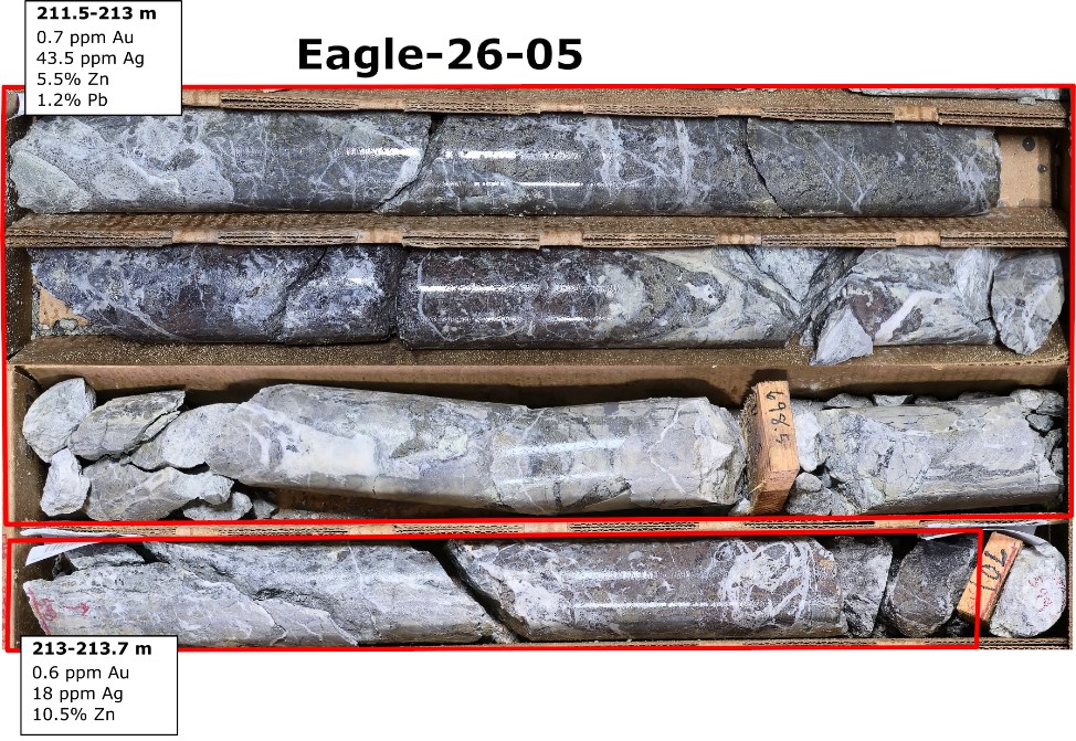
Figure 1. VMS mineralization in drill hole Eagle-26-05, located 200 m NE of the McCabe Mine, and 800m SW of three recently acquired past-producing silver mines (the Silver Parcels).
To view an enhanced version of this graphic, please visit:
https://images.newsfilecorp.com/files/10145/311283_7f065ddcf45ecbfc_002full.jpg
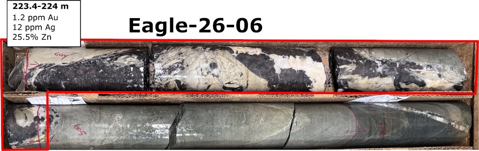
Figure 2. VMS mineralization in drill hole Eagle-26-06, located 200 m NE of the McCabe Mine, and 800m SW of three recently acquired past-producing silver mines (the Silver Parcels).
To view an enhanced version of this graphic, please visit:
https://images.newsfilecorp.com/files/10145/311283_7f065ddcf45ecbfc_003full.jpg
EAGLE-26-07 tested the southwestern extension of the mineralized structure near smaller-scale historical workings, including the Little Kicker shaft, where quartz-sulfide mineralization is exposed at surface. Although the target horizon was not intersected, drilling encountered gold mineralization typical of the McCabe system. The hole intersected two separate mineralized zones. The upper zone (from 122-130 m downhole) comprises an oxidized gossanous fault and shear zone developed along the contact between Cretaceous tonalite and Proterozoic metavolcanic rocks. A second, deeper zone (from 337-342 m downhole) comprises shear bands, veinlets, and fracture-fill sulphides, primarily pyrite and pyrrhotite, within strongly sericite-altered tonalite.
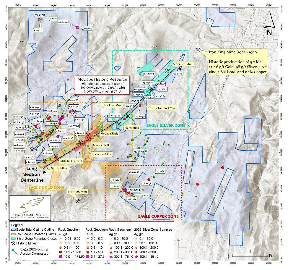
Figure 3. Plan map displaying Eagle Project patented and BLM claims totaling 4,169 acres.
To view an enhanced version of this graphic, please visit:
https://images.newsfilecorp.com/files/10145/311283_7f065ddcf45ecbfc_004full.jpg
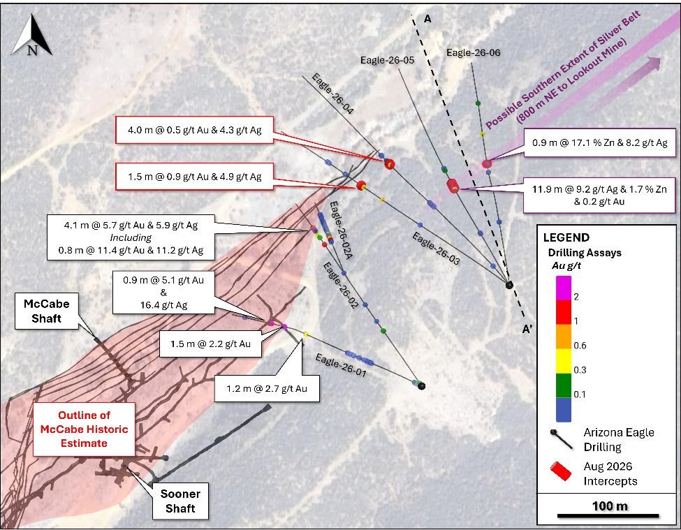
Figure 4. Plan view of Phase 1 drill holes numbers one through six.
To view an enhanced version of this graphic, please visit:
https://images.newsfilecorp.com/files/10145/311283_7f065ddcf45ecbfc_005full.jpg
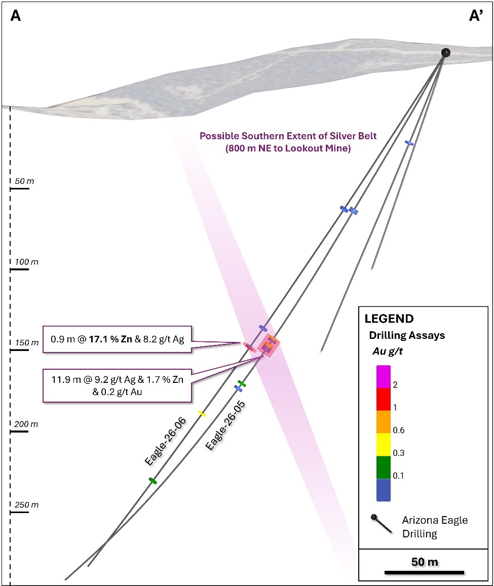
Figure 5. Cross section displaying holes 5 and 6, which intersected zinc-silver VMS type mineralization at a vertical depth of approximately 150 metres.
To view an enhanced version of this graphic, please visit:
https://images.newsfilecorp.com/files/10145/311283_7f065ddcf45ecbfc_006full.jpg
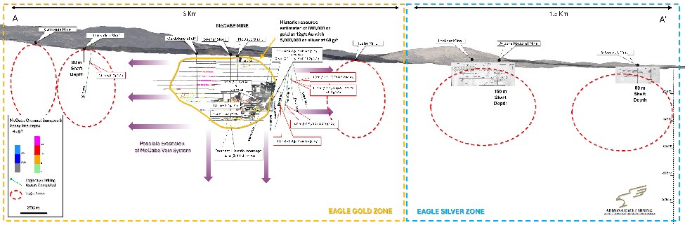
Figure 6. Long section showing drill targets at Eagle Gold Zone (3 km of strike), with Eagle Silver Zone extending to NE (1.5 km of strike).
To view an enhanced version of this graphic, please visit:
https://images.newsfilecorp.com/files/10145/311283_7f065ddcf45ecbfc_007full.jpg
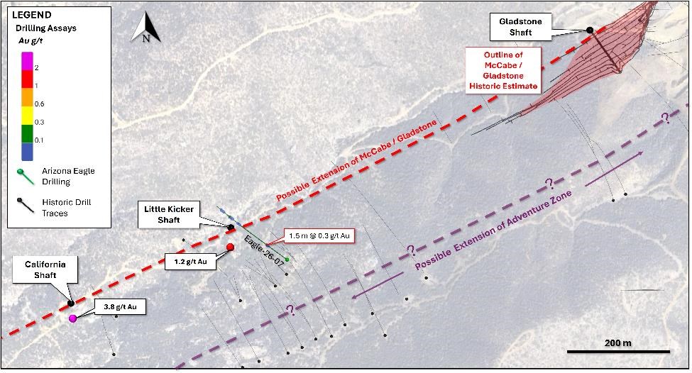
Figure 7. Plan map displaying drill hole Eagle-26-07 located approximately 600 metres southwest of the McCabe Mine. Although the target horizon was not intersected, drilling encountered gold mineralization typical of the McCabe system.
To view an enhanced version of this graphic, please visit:
https://images.newsfilecorp.com/files/10145/311283_7f065ddcf45ecbfc_008full.jpg
Eagle Project Overview
Arizona Eagle holds a 100% interest in the Eagle Project located in Yavapai County, Arizona. The Eagle Project is anchored by the past-producing gold and silver McCabe Mine, situated on 348 acres of private land. Stan West Mining historically invested more than US$35 million (approximately C$110 million in today’s dollars) to drill and develop the mine. In 1984, Stan West Mining published a historic estimate of
approximately 880,000 ounces of gold grading 11.7 g/t and 5 million ounces of silver grading 69 g/t (the Historical Estimate) 2, defined to a maximum depth of approximately 440 metres. and open in all directions. See “Cautionary Note Regarding the Historical Estimate” below.
Over the past two years, Arizona Eagle has expanded its total land position to 4,169 acres through staking and acquisitions surrounding the McCabe Mine, including a pending acquisition that will consolidate the Eagle Silver Project. During this time, the Company completed exploration programs focused on geological mapping, surface sampling, helicopter-borne VTEM surveys and ground-based induced polarization surveys that identified multiple parallel mineralized structures not historically drill-tested.
Cautionary Note Regarding the Historical Estimate.
The Historical Estimate is a historical estimate for the purposes of National Instrument 43-101 – Standards of Disclosure for Mineral Projects (“NI 43-101”). Its source is Knight, D.C., 1984, Stan West Mining Corp. McCabe-Iron King Belt project summary and financial information for shareholders, reporting a 1983 calculation by Derry, Michener, Booth & Wahl, there is no technical report on the Historical Estimate. Using the original terminology, it reported “Total Reserves” of 2,593,682 tons grading 0.34 ounces per ton (“opt”) (11.7 g/t) gold and 2.0 opt (69 g/t) silver, containing 877,617 ounces of gold and 5,119,169 ounces of silver, in categories described as “Proven”, “Probable – Drifting”, “Probable – Drilling”, “Possible” and “Geologically Inferred”, the last of which accounted for approximately 700,000 of the contained gold ounces. It was prepared at an assumed gold price of US$360 per ounce and covered approximately 750 to 800 metres of strike to a maximum depth of approximately 440 metres; other key assumptions, parameters and methods, including cut-off grades, are not known to the Company. The historical categories are not the mineral resource and mineral reserve categories set out in NI 43-101 and the CIM Definition Standards on Mineral Resources and Mineral Reserves (the “CIM Definition Standards”). “Geologically Inferred” is most closely comparable to an Inferred Mineral Resource and “Possible” to an Indicated to Inferred level of confidence, while the “Proven” and “Probable” categories, which are not supported by any pre-feasibility or feasibility study, are more comparable to Measured and Indicated Mineral Resources than to mineral reserves under the CIM Definition Standards. The categories were also aggregated into a single “Total Reserves” figure, which would not be permitted for a current estimate.
The Company considers the Historical Estimate relevant because it covers the McCabe deposit, the principal past-producing mine on the Eagle Project, and reflects a substantial body of historical drilling and underground development. Because the Historical Estimate predates NI 43-101 and the CIM Definition Standards, is not supported by a technical report and has not been verified by a Qualified Person, the Company regards it as an indication of the historical work completed at McCabe rather than as a measure of the quantity or grade of mineralization, and it should not be relied upon. Historical production at the McCabe Mine was at grades materially below those reported in the Historical Estimate. The Company is also aware of more recent historical estimates prepared for the McCabe deposit in 1989 and 1993, each of which was limited to material near the then-existing underground workings, was substantially smaller in scope than the Historical Estimate, and is likewise not compliant with the CIM Definition Standards or NI 43-101. Verifying or upgrading the Historical Estimate as current mineral resources would require significant work including but not limited to compilation and validation of the historical drilling, sampling and assay data, additional drilling, re-sampling and re-assaying under modern quality assurance and quality control protocols, geological and grade modelling and the establishment of cut-off grades and other economic parameters, with no certainty of success. A Qualified Person has not done sufficient work to classify the Historical Estimate or those more recent estimates as current mineral resources or current mineral reserves, the Company is not treating any of them as current mineral resources or current mineral reserves, the Historical Estimate is not being and may not be used in any economic analysis, and investors are cautioned not to rely on it.
Phase 1 Drill Program
In the first quarter of 2026, the Company initiated Phase 1 drill program of 7 holes. The drill program was designed in part to explore the lateral and vertical continuity of the McCabe veins in and around the historic resource. Results of the first 2 holes were announced on May 6th, 2026, with the remaining 5 holes released above.
Phase 2 Drill Program
The Company recently completed a sampling program on the newly acquired Silver Parcels, with results pending. A SkyTem geophysical survey is also planned to test for structural continuity between the McCabe Mine and the three past-producing silver mines, on strike to the northeast. Results of the sampling and geophysics will be used to define expansion targets on strike, as well as guide resource definition drilling at the McCabe Mine.
| HoleID | Easting | Northing | Elevation (m) |
Depth (m) |
Dip | Azimuth | Branch Depth (m) |
| Eagle-26-01 | 381779 | 3815951 | 1560 | 537 | -72 | 297° | – |
| Eagle-26-02 | 381779 | 3815951 | 1560 | 468 | -65 | 327° | – |
| Eagle-26-02a | 381779 | 3815951 | 1560 | 442 | -61.8 | 331° | 296 |
| Eagle-26-03 | 381866 | 3816051 | 1561 | 582 | -67 | 305° | – |
| Eagle-26-04 | 381866 | 3816051 | 1561 | 640 | -66.5 | 321° | – |
| Eagle-26-05 | 381866 | 3816051 | 1561 | 406 | -60 | 332° | – |
| Eagle-26-06 | 381866 | 3816051 | 1561 | 396 | -58 | 353° | – |
| Eagle-26-07 | 380674 | 3815336 | 1618 | 413 | -69 | 306° | – |
Table 2. Drill hole collar locations (all coordinates in datum WGS84 UTM Zone 12)
Sampling Procedures
All of Arizona Eagle’s drill sample assay results have been independently monitored through a quality assurance/quality control (“QA/QC”) protocol which includes the insertion of blind standard reference materials and blanks at regular intervals. Logging and sampling were completed at Arizona Eagle’s core handling facilities located near Dewey-Humboldt, Arizona. Drill core was diamond sawn on site and half drill-core samples were securely transported to ALS Laboratories’ (“ALS”) sample preparation facility in Tucson, Arizona. Sample pulps were sent to ALS’s labs in Vancouver, Canada for analysis.
Gold content was determined by fire assay of a 30-gram charge with ICP finish (ALS method Au-AA23). Silver and 32 other elements were analyzed by ICP methods with four-acid digestion (ALS method ME-ICP61a). Over-limit samples for Au, Ag, Cu, and Zn were determined by ore-grade analyses Au-GRA21, Ag-OG62, Cu-OG62, and Zn-OG62, respectively.
ALS Laboratories is independent of the Company. and its Vancouver facility is ISO 17025 accredited. ALS also performed its own internal QA/QC procedures to assure the accuracy and integrity of results. Parameters for ALS’ internal and Arizona Eagle’s external blind quality control samples were acceptable for the samples analyzed. The Company is not aware of any drilling, sampling, recovery, or other factors that could materially affect the accuracy or reliability of the data referred to herein.
About Arizona Eagle Mining Corp.
Arizona Eagle is a mineral exploration company focused on the acquisition, exploration and development of mineral properties. Arizona Eagle’s principal asset is the Eagle Project, a 4,169-acre property comprised of patented and unpatented claims located near the town of Prescott Valley in Yavapai County, Arizona. The Eagle Project is centered on the past-producing McCabe Mine, a high-grade gold-silver deposit, and includes multiple parallel structures hosting past-producing mines that remain largely untested by modern drilling. While Arizona Eagle’s primary focus will be on the exploration and development of the Eagle Project, it will continue to own Core Nickel’s land portfolio in the Thompson Nickel Belt of northern Manitoba.
The scientific and technical information contained in this news release has been reviewed and approved by Clyde Smith, PhD, Vice-President, Exploration of the Company, who is a Qualified Person as defined under National Instrument 43-101 – Standards of Disclosure for Mineral Projects. Mr. Smith supervised the drill program and verified the data disclosed, including sampling, analytical and QA/QC data, underlying the technical information in this news release, including reviewing the reports of ALS, methodologies, results, and all procedures undertaken for quality assurance and quality control in a manner consistent with industry practice, and all matters were consistent and accurate according to his professional judgement. There were no limitations on the verification process. Mr. Smith has also reviewed and approved the disclosure in this news release regarding the Historical Estimate; he has not, however, performed the work necessary to verify or upgrade the Historical Estimate as current mineral resources or current mineral reserves.
For Further Information
For further information on Arizona Eagle, please contact:
Kevin Reid, Chief Executive Officer and Director
Email: [email protected]
https://www.arizonaeaglemining.com/
Cautionary Statement Regarding Forward-Looking Statements
This news release contains forward-looking statements and forward-looking information (collectively, “forward-looking statements”) within the meaning of applicable securities laws. Any statements that are contained in this news release that are not statements of historical fact may be deemed to be forward-looking statements. Forward-looking statements are often identified by terms such as “may”, “should”, “anticipate”, “will”, “estimates”, “believes”, “intends”, “expects” and similar expressions which are intended to identify forward-looking statements. More particularly and without limitation, this news release contains forward-looking statements, including statements concerning the Company’s exploration activities and the Phase 1 Drill Program at the Eagle Project, the expected timing and receipt of assay results, the mobilization of additional drill rigs, the potential to define additional mineralization in and beyond the area covered by the Historical Estimate, and the pending acquisition to consolidate the Eagle Silver Project. Statements concerning the Historical Estimate may also be deemed to constitute forward-looking information to the extent that they involve estimates of the mineralization that would be encountered if the Eagle Project were developed. Forward-looking statements are inherently uncertain, and actual performance may be affected by a number of material factors, assumptions and expectations, many of which are beyond the control of the Company, including expectations and assumptions concerning the Company’s ability to complete the Eagle Silver Project acquisition on the proposed terms or at all (including the completion of satisfactory due diligence, the timely receipt of all required regulatory approvals, including the approval of the TSXV, and the Company’s ability to obtain clear title to the underlying mineral claims), the Company’s ability to execute on the Phase 1 Drill Program at the Eagle Project, the Historical Estimate and historical information prepared by prior operators of the Eagle Project, commodity price fluctuations, the availability of financing on acceptable terms, environmental and permitting risks, and risks inherent in mineral exploration and development. Readers are cautioned that assumptions used in the preparation of any forward-looking statements may prove to be incorrect. Events or circumstances may cause actual results to differ materially from those predicted as a result of numerous known and unknown risks, uncertainties and other factors, many of which are beyond the control of the Company. Readers are further cautioned not to place undue reliance on any forward-looking statements, as such information, although considered reasonable by management of the Company at the time of preparation, may prove to be incorrect and actual results may differ materially from those anticipated. The forward-looking statements contained in this news release are made as of the date of this news release and are expressly qualified by the foregoing cautionary statement. Except as expressly required by securities law, the Company does not undertake any obligation to update publicly or to revise any of the included forward-looking statements, whether as a result of new information, future events or otherwise.
Neither the TSX Venture Exchange nor its Regulation Services Provider (as that term is defined in the policies of the TSX Venture Exchange) accepts responsibility for the adequacy or accuracy of this news release. No stock exchange, securities commission or other regulatory authority has approved or disapproved the information contained herein.
1 The Iron King Mine is not part of the Eagle Project and the Company has no interest in it. Historical production figures for the Iron King Mine are taken from historical records and have not been verified by the Company’s Qualified Person. Mineralization hosted on adjacent or nearby properties is not necessarily indicative of mineralization hosted on the Eagle Project.
2 The Historical Estimate is a historical estimate for the purposes of NI 43-101. It is not current, is not being treated by the Company as current mineral resources or current mineral reserves, and should not be relied upon. A Qualified Person has not done sufficient work to classify the Historical Estimate as current mineral resources or current mineral reserves. See “Cautionary Note Regarding the Historical Estimate” in this news release for the source, date, relevance, reliability, known assumptions and parameters, category comparison and required verification work.
To view the source version of this press release, please visit https://www.newsfilecorp.com/release/311283