

Visakhapatnam.
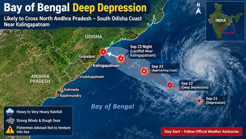
The India Meteorological Department (IMD) has issued critical weather advisories as a Deep Depression over the west-central and adjoining northwest Bay of Bengal moves rapidly west-northwestward toward the east coast.
Landfall Expected Near Kalingapatnam
The weather system is slated to make landfall between Visakhapatnam (Andhra Pradesh) and Gopalpur (Odisha), close to Kalingapatnam, during the night of September 23. Strong surface winds and heavy rainfall are expected to persist well into the morning hours of September 24.
+——————————————————————————-+
| SYSTEM PROFILE |
| Classification : Deep Depression (Bay of Bengal) |
| Target Coast : North Andhra Pradesh – South Odisha |
| Focal Point : Close to Kalingapatnam (between Visakhapatnam & Gopalpur) |
| Impact Timeline: Night of Sept 23 through early hours of Sept 24 |
+——————————————————————————-+
Regional Impacts Breakdown
1. North Coastal Andhra Pradesh
- Districts Affected: Srikakulam, Vizianagaram, Parvathipuram Manyam, and Alluri Sitharama Raju (ASR).
- Expected Conditions: Widespread heavy to very heavy rainfall, with isolated areas experiencing extremely heavy downpours. Squally wind conditions will prevail along the coast.
2. South Odisha Coast
- Districts Affected: Ganjam, Gajapati, Rayagada, Koraput, and Malkangiri.
- Expected Conditions: Intense precipitation accompanied by strong winds and rough to very rough sea conditions. Local administration is on high alert for urban waterlogging and flash floods.
3. Karnataka (Red Alert Issued)
- September 23: State-wide Orange Alert with increased shower activity.
- September 24: Red Alert issued for Coastal Karnataka. Heavy showers, lightning, and strong gusts are predicted to impact both coastal and South Interior Karnataka districts.
Emergency Safety Advisory
- Fishermen Warning: Strictly avoid venturing into the west-central and northwest Bay of Bengal and coastal waters until conditions normalize.
- Travel Alert: Avoid non-essential travel in flood-prone and landslide-sensitive hilly tracks across northern AP and southern Odisha.
- Coastal Safety: Stay away from beaches and low-lying coastal embankments subject to high tidal surges.
Frequently Asked Questions (FAQ)
Q1: Is this weather system classified as a cyclone?
No, as per official updates, the system is classified as a Deep Depression, which is one stage below a tropical cyclonic storm.
Q2: Which areas are under a Red Alert on September 24?
Coastal Karnataka is placed under a Red Alert for September 24 due to intense downpours and squally weather.
Q3: When will the weather conditions begin to clear up?
Atmospheric conditions are expected to gradually improve late on September 24 as the system moves further inland and weakens.
Disclaimer
This article is compiled based on official meteorological bulletins and public safety releases available on September 23. Local administrative advisories and state disaster guidelines should always take precedence during extreme weather events.
Related News & Updates:
Stay informed with real-time coverage and regional weather trackers on Matribhumi Samachar.
