



Vancouver, British Columbia–(Newsfile Corp. – November 9, 2026) – Flow Metals Corp. (CSE: FWM) (“Flow Metals” or the “Company“) is pleased to announce that it has completed a 3D geophysical data compilation and data re-processing program at its flagship Sixtymile Gold Project in western Yukon. The program was carried out by in3D Geoscience Inc., under the direction of Todd Ballantyne, P.Geo. The 3D data compilation promotes the evaluation of the subsurface structures of the Sixtymile Valley copper-molybdenum porphyry and epithermal gold-silver targets.
Highlights
- 3D Subsurface Resistivity Model: 27.9 line-kilometers of historical controlled-source audio-frequency magnetotelluric (“CSAMT”) data were reprocessed from the original 2D inversions into a unified 3D resistivity block model.
- 3D Mapping of Structures and Fluid Pathways in 3D: Connecting 2D cross sections into a continuous volume allows the team to trace fault geometry and correlate resistivity domains with historic drill intercepts.
- Major Faults and Alteration Domains Delineated: The 3D model resolves the Sixtymile Fault zone, cross-cutting structures, and distinct resistivity domains. These coincide with hydrothermal alteration, brecciation, and anomalous copper-molybdenum and silver-gold intervals in historical drill core.
- Mineral Systems Approach to Focus Exploration: Evaluating these 3D domains within a mineral systems framework allows the Company to deprioritize areas that lack key subsurface features. Geophysical and drilling work can then focus on specific, testable porphyry and epithermal targets.
“While gold remains our primary focus at Sixtymile, the Sixtymile Valley option gives us an exciting opportunity to broaden into critical minerals,” said Scott Sheldon, President and CEO of Flow Metals. “Combining this new 3D subsurface model with our recent surface discoveries and the encouraging historic copper-molybdenum drill results lets us look beneath the valley, connect the dots across the system, and prioritize our next phase of exploration.”
Expanding Gold and Critical Mineral Potential
The Company optioned the Sixtymile Valley target area as part of its 2026 district consolidation (see news release dated August 6, 2026) which added a critical minerals component to the project’s primary gold focus. Historical drilling in the target area intersected porphyry-style alteration and brecciation with anomalous copper, molybdenum, silver, and gold.
Surface mapping competed by the Company in 2026 found pervasive clay alteration and vuggy residual quartz at Miller Creek. This indicates that the uppermost levels of a high-sulphidation epithermal system may be preserved. Taken together with the historic porphyry drill intercepts, these observations suggest the valley could host a pristine calc-alkaline porphyry-epithermal system. In systems of this type, alteration and fluid pathways typically generate sharp electrical resistivity contrasts between conductive, clay-altered fault zones and resistive silica caps or intrusive stocks. The Company initiated the 3D CSAMT modelling program to map these subsurface features and test how they connect at depth.
3D Subsurface Resistivity Model of the Sixtymile Valley
CSAMT is an electromagnetic survey method that measures differences in electrical resistivity of subsurface rocks to depths of several hundred meters. In porphyry and epithermal systems, fluid-bearing faults and clay-sulphide alteration typically form low-resistivity (conductive) zones. Quartz-flooded breccias, silicified caps, and intrusive stocks typically form high-resistivity bodies.
In 2011, the historical operator completed 27.9 line-kilometers of CSAMT along 27 survey lines over the Sixtymile Valley target. Those data were evaluated primarily as isolated 2D cross-sections. This year, Flow Metals engaged in3D Geoscience to re-grid the 2D inversions into one continuous 3D block model, to improve the visualization of how the structures and alteration zones connect between the sections.
The 3D model shows a branching network of steeply dipping conductive structures alongside large high- and low-resistivity domains. Plotting the 2011 drill holes are plotted within the model, these domains and structural trends broadly correlate with intervals of hydrothermal alteration, brecciation, and anomalous polymetallic mineralization. This gives the Company a framework for tracing the system into undrilled areas.
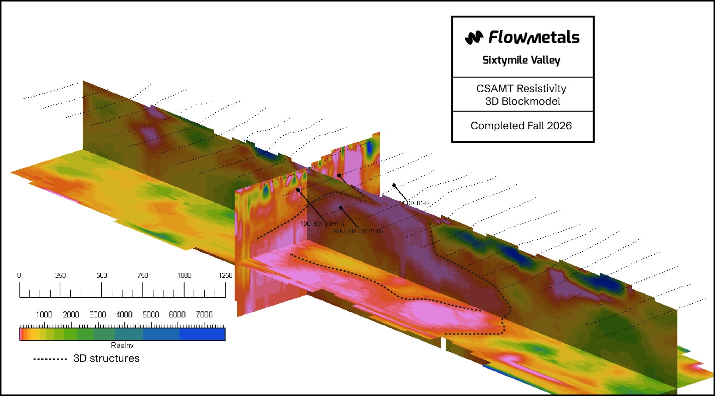
Figure 1: Orthogonal slices through the 3D resistivity block model. Low resistivity (conductive) domains are shown in warm colours and highly resistive domains in cool colours. High resolution image.
To view an enhanced version of this graphic, please visit:
https://images.newsfilecorp.com/files/7235/322969_96e75910a4474966_001full.jpg
Next Steps
With the initial 3D resistivity block model and domain clustering complete, the technical team is now digitizing the primary fault architecture in 3D space and cross-referencing the resistivity volumes against newly filtered 2010 airborne magnetic grids. The Company will also drape its 2026 surface mapping over the block model to trace the newly identified epithermal and lithocap zones to depth, while conducting a statistical analysis of historical drill logs and assay intervals against the geophysical clusters, to establish quantitative vectors for future drill targeting.
Qualified Person
The technical content of this news release has been reviewed and approved by Harley Slade, P.Geo., a director of the Company, who is a Qualified Person as defined by National Instrument 43-101 – Standards of Disclosure for Mineral Projects.
The historical CSAMT, airborne magnetic, and drilling data referred to in this news release were produced by a previous operator. The Qualified Person has not independently verified these historical data. The Company considers the historical data relevant as a guide to exploration. However, readers are cautioned that the historical results may not be reliable and are not necessarily indicative of mineralization on the property.
About the Company
Flow Metals is a Canadian mineral exploration company focused on the discovery and advancement of district-scale gold and critical mineral projects. The Company’s flagship Sixtymile Gold Project in Yukon covers a significant portion of a historic placer gold district, where exploration is targeting the bedrock sources of gold alongside emerging epithermal gold-silver and copper-molybdenum porphyry opportunities. Flow also owns the New Brenda Project in southern British Columbia, a copper-molybdenum porphyry exploration project located within the Quesnel Terrane.
For further information, please contact:
Scott Sheldon, President and CEO
604.725.1857
[email protected]
The Canadian Securities Exchange (operated by CNSX Markets Inc.) has neither approved nor disapproved of the contents of this news release.
Forward-Looking Information
This news release contains “forward-looking information” and “forward-looking statements” within the meaning of applicable Canadian securities laws (together, “forward-looking statements“). Forward-looking statements in this news release include statements about the interpretation of the 3D resistivity model and its use in exploration targeting; the potential for the Sixtymile Valley target area to host a preserved porphyry-epithermal system; the Company’s planned modelling, data integration and next phase of exploration; and the Company’s ability to meet its obligations under the Sixtymile Valley option agreement.
These statements are based on assumptions that management considers reasonable, including that the historical data are reasonably accurate, that the model’s interpretation is reasonable, and that the Company will obtain financing, permits and access in a timely way. Actual results may differ materially because of risks and uncertainties. These include the inherent uncertainty of geophysical interpretation; the reliability of historical data; the risk that interpreted features do not correspond to economic mineralization; the Company’s ability to raise funds and meet its option obligations; delays related to permitting and First Nations consultation; commodity prices; weather and seasonal access in Yukon; and the other risks described in the Company’s continuous disclosure documents, available on SEDAR+ at www.sedarplus.ca.
Readers are cautioned not to place undue reliance on forward-looking statements. These statements are made as of the date of this news release, and the Company does not undertake to update them, except as required by applicable securities laws.

To view the source version of this press release, please visit https://www.newsfilecorp.com/release/322969