New Delhi. Monday, 15 June 2026
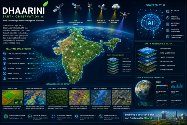
Artificial Intelligence has officially crossed the threshold from a localized corporate asset to a critical pillar of global economics, national security, and societal architecture. As countries race to build localized computing layers, India is taking an ambitious leap forward in deep-tech innovation. Moving beyond text-centric Large Language Models (LLMs), the nation is establishing native capabilities to decode the physical world through Dhaarini—a next-generation, sovereign Large Earth Observation Model (LOM).
Developed by Bengaluru-based geospatial analytics pioneer SatSure, Dhaarini represents a fundamental shift from conventional, static satellite data analysis to continuous, AI-driven planetary intelligence.
What is Dhaarini? India’s Indigenous Earth Intelligence Layer
Dhaarini is a specialized, foundation AI model trained on massive volumes of multi-source geospatial data. Much like conversational AI models learn semantic patterns from human text, Dhaarini is engineered to learn spatial, structural, and environmental patterns directly from the Earth’s surface.
The system acts as a highly reusable, foundational intelligence layer. Instead of requiring organizations to train separate, isolated data models for different use cases, Dhaarini establishes a centralized, pre-trained core. This foundational framework can be tapped by developers, government departments, and businesses to deploy specialized applications across multiple sectors instantly.
Why India Requires a Hyper-Localized, Sovereign AI Model
For years, Indian enterprises and government agencies have relied heavily on global geospatial tech stacks. However, generalized global models consistently struggle to accurately interpret India’s complex, highly distinct geographic realities.
Overcoming the Flaws of Global Geographic Models
-
The Monsoon Factor: India’s climate is heavily governed by complex monsoon patterns and sharp rainfall variabilities that require localized temporal understanding.
-
Fragmented Agriculture: Unlike the massive, uniform corporate farms of Western nations, India’s agricultural landscape is characterized by highly fragmented, small-scale family landholdings with diverse intercropping patterns.
-
Hyper-Accelerated Urbanization: Indian cities expand at unprecedented speeds, creating dense urban-rural interfaces that traditional spatial algorithms frequently misclassify.
By training exclusively on India-centric datasets, Dhaarini accurately tracks local crop health cycles, maps flood-prone topographies, pinpoints structural encroachment, and optimizes national infrastructure corridors without external technological dependencies.
Under the Hood: 4 Core Technological Features
Dhaarini differentiates itself from standard satellite imagery software through four advanced computational pillars:
┌────────────────────────────────────────────────────────┐
│               DHAARINI ARCHITECTURE                    │
├────────────────────────────────────────────────────────┤
│ 🛰️ Multimodal Fusion : Optical + Radar (SAR) + Weather │
├────────────────────────────────────────────────────────┤
│ ⏳ Temporal View    : Tracks changes over time         │
├────────────────────────────────────────────────────────┤
│ 📐 Multi-Scale      : National down to field-level     │
├────────────────────────────────────────────────────────┤
│ 🧠 Geo-Embeddings   : Reusable sectoral foundation    │
└────────────────────────────────────────────────────────┘
-
Multimodal Data Processing: The architecture seamlessly fuses optical satellite imagery with Synthetic Aperture Radar (SAR), LiDAR data, drone telemetry, and real-time ground weather networks to construct a holistic view of the terrain.
-
Temporal Intelligence: Traditional mapping relies on single, isolated snapshots. Dhaarini evaluates continuous historical sequences, allowing the model to grasp seasonal fluctuations, multi-year climate shifts, and progressive infrastructure expansion.
-
Multi-Scale Analysis: The system operates dynamically across scales, delivering macro insights for national-level policy formulation down to granular, micro-level data for precise field monitoring.
-
Geospatial Embeddings: By converting geographical traits into high-dimensional mathematical vectors (embeddings), the platform enables downstream software to inherit deep Earth intelligence without undergoing heavy, expensive model retraining.
Transforming Critical Sectors Across the Indian Economy
The real-world applications of this indigenous Earth observation layer span the entire economic and governance spectrum:
-
Precision Agriculture: Enables automated crop monitoring, macro yield forecasting, regional drought assessments, and predictive pest-risk modeling to safeguard food security.
-
Disaster Management: Delivers automated, early-warning insights for landslides, cyclones, and floods, allowing emergency response teams to plan evacuation corridors dynamically.
-
Smart City Planning: Assists municipal corporations in monitoring large-scale infrastructure corridors, identifying land encroachments, and tracking illegal environmental degradation.
-
Climate Risk Financials: Empowers banks and insurance institutions to run data-driven risk modeling for agricultural lending, carbon credit verification, and infrastructure financing.
Strategic Funding and the Indian Spacetech Boom
The birth of Dhaarini arrives amidst an unprecedented surge in the domestic private space tech ecosystem, heavily accelerated by the Indian National Space Promotion and Authorisation Centre (IN-SPACe).
To transition the platform from conceptual research to population-scale commercial viability, SatSure officially secured a massive grant of approximately $2.57 million (around ₹24.6 crore) from India’s space regulator under the strategic Technology Adoption Fund (TAF). This financial and regulatory backing places India in an elite, self-reliant group of nations investing heavily in sovereign AI models capable of processing large-scale Earth observation data.
As geopolitical landscapes shift and climate challenges intensify, platforms like Dhaarini ensure that India maintains absolute digital sovereignty over its geographical data, engineering a highly resilient, data-driven blueprint for sustainable development.
Relevant Links for Further Reading
-
To discover how private space sector startups are scaling indigenous deep-tech under structural policy overhauls, read the full report on How IN-SPACe and Private Innovators are Propelling the India Space Tech Ecosystem to New Heights.
-
To explore how India’s technical architectures fit into localized data frameworks and independent policy blueprints, explore the analysis on Scaling Responsible Innovation: The Evolution of Global AI Governance and India’s Strategic Path.